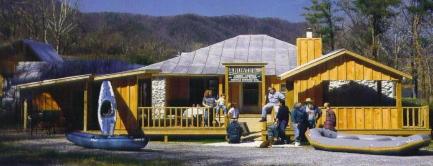
The Nolichucky River
Enjoy the whitewater of the Nolichucky River. Run the 10.5 miles of Class III-IV rapids. The
first half is filled with spectacular drops, big wave action, and large boulders while the
second half allows you to take advantage of the scenery that you didn't have a chance to
notice on the first half. These sections are in Poplar, North Carolina to Erwin, Tennessee
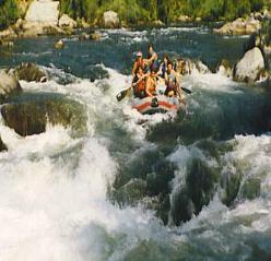
The Nolichucky River's churning white water winds through the deepest gorge in the eastern United States. The scenery is spectacular with steep slopes and cliffs rising more than 2,000 feet from the magnificent river. There is public boat access upstream in Poplar, North Carolina, as well as a take-out at Chestoa in Erwin, Tennessee.
The Nolichucky Gorge in the Appalachian's Unaka Mountains of western North Carolina and eastern Tennessee provides a spectacular backdrop for rafting on the Nolichucky River. Throughout much of the gorge, the walls rise more than 2,800 feet above the river, which originates on the slopes of Mount Mitchell--at 6,684 feet, eastern America's highest point. The Clinchfield Railroad line follows the entire river course between Poplar, North Carolina, and Erwin, Tennessee. The first half of the 10-mile (16-km) Nolichucky trip is the most intense. Large boulders, giant waves, and a gradient dropping at a rate of 66 feet per mile create numerous long Class III-IV+ rapids, such as On the Rocks, Jaws, Quarter Mile, Rooster Tail, and The Sousehole. This portion of the river requires active rafter participation, leaving little time to enjoy the passing scenery. The high water rafting season on the Nolichucky, a free- flowing river through the Pisgah and Cherokee national forests, usually lasts only from early March until mid-June. During the summer months when water levels on the Nolichucky become too low for large rafts, outfitters offer guided trips using smaller rafts and inflatable kayaks. These low water runs are popular with families, seniors, the disabled, and vacationers just wanting to relax and enjoy the beautiful scenery. On warm summer days, outfitters allow time for swimming and hiking.
The Nolichucky River is a major stream draining the Blue Ridge Mountains of western
North Carolina and East Tennessee. The Nolichucky River rises as the confluence of the
North Toe River and the Cane River near the community of Huntdale. The stream
succeeds the North Toe as the boundary between Yancey County and Mitchell County,
North Carolina. Trending roughly westward, it flows along the north flank of Flattop
Mountain. The gorge is especially steep on its north side. Geologically, the area is
underlain by predominantly by metamorphic rock of Precambrian time. The river then
enters Unicoi County, Tennessee, flowing through ranges known locally as the Bald
Mountains and the Unaka Mountains. Turning northwest, the stream is bridged by the
Appalachian Trail, and then, just beyond this, by U.S. Highway 19W southwest of the Unicoi
County seat of Erwin. Near Erwin, two tributary streams, South Indian Creek and North
Indian Creek, join the Nolichucky River. Turning more to the north, the stream is
paralleled for several miles by State Route 81 (known locally as Nolichucky River Road),
crossing into Washington County. The river cuts between several mountains at this point,
including Rich Mountain to the south and Buffalo Mountain to the north. The stream is a
popular white water rafting and canoeing destination since it has stretches of both white
water areas and calm water. Between Poplar, North Carolina and Unaka Springs,
Tennessee, the river provides one of the most scenic whitewater trips in the South.
From Wikipedia, the free encyclopedia
From Wikipedia, the free encyclopedia
The Nolichucky River's churning white water winds through the deepest gorge in the eastern United States. The scenery is spectacular with steep slopes and cliffs rising more than 2,000 feet from the magnificent river. There is public boat access upstream in Poplar, North Carolina, as well as a take-out at Chestoa in Erwin, Tennessee.
The Nolichucky Gorge in the Appalachian's Unaka Mountains of western North Carolina and eastern Tennessee provides a spectacular backdrop for rafting on the Nolichucky River. Throughout much of the gorge, the walls rise more than 2,800 feet above the river, which originates on the slopes of Mount Mitchell--at 6,684 feet, eastern America's highest point. The Clinchfield Railroad line follows the entire river course between Poplar, North Carolina, and Erwin, Tennessee. The first half of the 10-mile (16-km) Nolichucky trip is the most intense. Large boulders, giant waves, and a gradient dropping at a rate of 66 feet per mile create numerous long Class III-IV+ rapids, such as On the Rocks, Jaws, Quarter Mile, Rooster Tail, and The Sousehole. This portion of the river requires active rafter participation, leaving little time to enjoy the passing scenery. The high water rafting season on the Nolichucky, a free- flowing river through the Pisgah and Cherokee national forests, usually lasts only from early March until mid-June. During the summer months when water levels on the Nolichucky become too low for large rafts, outfitters offer guided trips using smaller rafts and inflatable kayaks. These low water runs are popular with families, seniors, the disabled, and vacationers just wanting to relax and enjoy the beautiful scenery. On warm summer days, outfitters allow time for swimming and hiking.